
This article is about the Scottish burgh. For other places with the same name, see Roxburgh (disambiguation).
Coordinates:
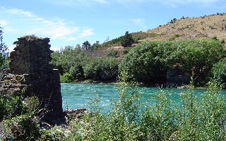
The destroyed Royal Burgh of Roxburgh, was an important trading burgh in High Medieval to Early Modern Scotland. In the Middle Ages it had at least as much importance as Edinburgh, Stirling, or Berwick-upon-Tweed, for a time acting as de facto capital as the royal residence of David I. Its significance lay in its position in the centre of some of Lowland Scotland's most agriculturally fertile areas, and its position upon the River Tweed, which allowed river transport of goods via the main seaport of Berwick-upon-Tweed. Its position also acted as a barrier to English invasion.
The town stood on a defensible peninsula between the rivers Tweed and Teviot, with Roxburgh Castle guarding the narrow neck of the peninsula. Nothing remains of the town except some ruined segments of castle ramparts. Its site lies to the south of modern Kelso and Floors Castle, which lie on the other side of the Tweed. The Duke of Roxburghe owns the site.
English and Scots forces repeatedly captured and recaptured the town during the Scottish Wars of Independence. Its final recapture in 1460 saw the town and castle destroyed. After this time the town never regained its importance because the final English capture of Berwick-upon-Tweed in 1482 left Roxburgh with little reason to exist.
Roxburgh was superseded as the county town of the former county of Roxburghshire by Jedburgh.
(See: http://www.channel4.com/history/timeteam/2004_rox_ancient.html )
Roxburgh District
In more recent times (1975–1996), Roxburgh referred to a local government district in the Borders region of Scotland. Its borders broadly resembled those of the traditional county of Roxburghshire. In 1996 the district of Roxburgh became part of the Scottish Borders unitary area. (See also: Subdivisions of Scotland)
No comments:
Post a Comment